

MENDOTA – Wide temperature swings were the norm in November throughout Illinois, but will that trend continue all winter?
This item is available in full to subscribers.
To continue reading, you will need to either log in to your subscriber account, or purchase a new subscription.
If you are a current print subscriber, you can set up a free website account and connect your subscription to it by clicking here.
If you are a digital subscriber with an active, online-only subscription then you already have an account here. Just reset your password if you've not yet logged in to your account on this new site.
Otherwise, click here to view your options for subscribing.
Please log in to continue |
MENDOTA – Wide temperature swings were the norm in November throughout Illinois, but will that trend continue all winter?
In a recap of the November weather, Illinois State Climatologist Jim Angel reported that the overall temperature for the month ended up slightly cooler than average statewide because the colder-than-normal temperatures during part of the month canceled out the warmer-than normal days.
The statewide average temperature last month was 41.7 degrees, 0.8 degrees below normal. Northern Illinois experienced 1 to 2 degrees below normal, while the area around St. Louis was 1 to 2 degrees above normal. The warmest reading in the state last month was a balmy 79 degrees at Belleville on Nov. 2. The coldest reading was 11 degrees at Stockton on Nov. 24.
The statewide average precipitation was 2.13 inches, which is 1.34 inches below normal. In most areas, all of the precipitation was in the form of rain, although some snow was reported in northern and central Illinois. The largest snowfall amount was 1.5 inches at the Chicago Botanic Garden.
For the traditional three-month fall period, September through November, Angel said the statewide average temperature was 56.2 degrees, 1.8 degrees above normal and the 15th warmest fall on record.
On the other hand, the statewide average precipitation for fall measured just 7.72 inches, which is 2.22 inches below normal. In southern Illinois, the very dry conditions near St. Louis resulted in the U.S. Drought Monitor calling for moderate to severe drought from Randolph to Calhoun counties.
Winter forecast
Judging by the very warm start to December, this month may be headed in the same direction as November. Temperatures reaching close to 60 degrees the first few days of December brought many people outside to attend special holiday events and finish up their outdoor Christmas decorating. Locally, this unseasonably warm start to December has been followed by howling winds and a drastic drop in temperatures. Is this a sign of the weeks to come or are we in store for another mild winter?
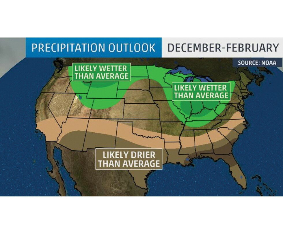
NOAA (National Oceanic and Atmospheric Administration) says maybe. NOAA, which gives very general weather probabilities for the coming season, reminds the public that long-term forecasts are generally unreliable and that their weather “probabilities” are not “certainties.” NOAA’s predictions give percentages for the chance of below-, near- or above-average climate outcomes and their maps show only the “most likely” outcome.
With that in mind, the western half of Illinois has been given a 33-40 percent chance of having a wetter than normal winter, while the Eastern half of the state has a 40-50 percent chance of a wetter than normal winter. For LaSalle County, which lies right along the east-west dividing line on the map, those precipitation chances could go either way. Additionally, NOAA emphasizes that “wetter than normal” does not imply that this winter will be snowier-than-normal.
As for temperatures this winter, Illinois did not receive a strong above- or below-average prediction from NOAA. Like much of the midsection of the country, the state is given “equal chances” for above-, near- or below-normal temperature. Again, NOAA stresses this does not mean there will be near-average temperatures this winter but rather, there is no tilt in the odds toward any of the three outcomes. This is in contrast to the northwest region, which is above-average for a colder winter, and the entire southern and eastern sections of the country, which received an above-average probability for a warmer winter.
Farmer’s Almanac
Other less-scientific sources also provide long range weather predictions each year. One of the most well known, the Farmer’s Almanac, makes their forecasts 18 months in advance and claims to be 80 percent accurate. While that accuracy rate is disputed by some, the Almanac says their predictions are meant to help farmers make “more informed decisions for long-term planning.”
Illinois, which the Farmer’s Almanac categorizes as part of the Lower Lakes Region, is predicted to have a warmer than normal winter with slightly above-normal precipitation. They list the coldest periods as early- to mid-December, early January and mid-February. Snowfall will be below normal throughout the region (except for Ohio) with the snowiest periods in early- to mid-December, late December, early January and early February.
More specifically, the Almanac predicts mild but rainy conditions around Christmas, then turning colder by New Year’s Eve with some snow showers. January is expected to return to mostly mild conditions.
For many people, another mild winter is welcome news. On the other hand, people who prefer a cold, snowy winter season may be disappointed. Still, the winter enthusiasts can take comfort in knowing that long range weather prediction is unreliable at best. And in Illinois, as always, it is wise to prepare for the unexpected when it comes to weather!


